Everyone Misread the Oak Island Treasure Map… The Real Clue Was Hidden in Plain Sight!
Oak Island Mystery Deepens: Could the Maps Have Been Leading Searchers Astray All Along?
For decades, the Oak Island treasure hunt has captivated historians, adventurers, and television audiences alike. The team led by Rick Lagina, alongside Marty Lagina, Alex Lagina, and other key members, has relentlessly pursued clues that many believe could unveil one of history’s greatest hidden treasures. Their work has uncovered ancient artifacts, mysterious structures, and tantalizing hints of centuries-old secrets. Yet, recent developments suggest that one of the most crucial elements in the hunt may have been misunderstood from the outset.
At the heart of this new perspective is a set of Oak Island treasure maps. Historically assumed to guide searchers toward the legendary Money Pit, these maps may, in fact, have been intentionally misleading. Careful analysis of the symbols, directions, and markings suggests a startling possibility: rather than pointing to treasure, the maps might have been designed to steer explorers away from it. If true, decades of excavation and millions of dollars invested may have followed a false trail for over two centuries.
The latest breakthrough centers on two anchor stones discovered along the island’s shores. Steve Guptil, following a path drawn from a 15th-century French map, identified a massive boulder on the northern shore that appeared nearly identical to another stone on the southern side. Carved markings on the stones—resembling either a cross, a letter T, or a ship—suggested they were more than natural formations. The anchor stones, as researcher Aaron Hilton theorized, could serve as reference points to triangulate the exact location of the Money Pit vault. Remarkably, lines drawn connecting these markers converged almost precisely on a previously excavated steel shaft, demonstrating a level of precision that hinted at sophisticated geometric planning centuries before modern surveying techniques existed.
Further afield, clues emerged from Massachusetts. The so-called “boat stone,” a 250-pound boulder etched with symbols such as a ship, an arrow, and the number 184, was proposed by researcher Robert Marcus to be a navigational guide connected to Oak Island. Some theorists suggest that Scottish Templar Henry Sinclair may have sailed to Nova Scotia in 1398, using these markers to safeguard valuable relics. The similarities between the Massachusetts boat stone and the newly discovered anchor stones on Oak Island have lent credence to the idea that both sites were part of a coordinated system, potentially constructed by a group employing advanced geometry to protect their secrets.
The intrigue deepened with the discovery of ancient maps held by researcher Zena Halpern. One map, allegedly from 1179, depicted locations on Oak Island with remarkable detail, including areas now recognized as the swamp, low-lying marshlands, and man-made structures such as dams and wooden walls. Labels on the map corresponded with key features the team had uncovered, including anchors, valves, and even a mysterious hatch. Halpern’s maps suggested a network of tunnels beneath the island, implying a deliberate and sophisticated plan for concealment. Overlaying these centuries-old drawings onto modern satellite imagery revealed astonishing accuracy, reinforcing the possibility that Oak Island’s original architects engineered the landscape itself as part of a treasure protection system.

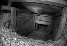


Adding another layer of intrigue, Dave Blankenship stumbled upon an unusual depression in the western woods, far from the Money Pit’s usual focus. The square shape and loose soil suggested deliberate excavation, potentially marking a hidden entrance to the island’s underground network. This discovery aligned closely with the ancient maps and offered the tantalizing possibility that the island’s greatest secrets remained just beyond reach, preserved for centuries from casual or untrained explorers.
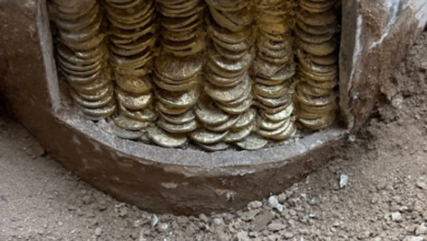
The implications of these findings are profound. If the maps were indeed designed to mislead, Oak Island’s legendary treasure might have been concealed in plain sight, with only those capable of interpreting the geometric and symbolic clues able to approach it. Some researchers speculate that the hidden vault could contain artifacts of immense historical significance, from the Ark of the Covenant to the golden menorah from King Solomon’s temple. Each stone, carving, and marker may have been part of an elaborate system, combining navigational precision with centuries-old secrecy.
For Rick Lagina and the team, the hunt has evolved far beyond digging. Every discovery, from anchor stones to ancient maps and hidden depressions, has reinforced the notion that Oak Island is less a random treasure site and more a centuries-old puzzle crafted with intention and expertise. As Aaron Hilton and other researchers continue their analysis, the convergence of historical maps, archaeological findings, and modern technology could finally bring clarity to a mystery that has endured for over 200 years.
The Oak Island saga remains one of the most compelling stories of modern exploration. As each new clue emerges, the narrative shifts, offering both hope and caution: that the greatest treasure may be hidden not just beneath the soil, but in the careful interpretation of the past, waiting for those with the insight to see what others have overlooked.