Ancient Engineers Marked the Spot: New Evidence Shows Where the Real Money Pit Lies
Ancient Measurements, Shifting Shorelines and a 500-Year Puzzle: Re-examining Oak Island’s Mysterious Money Pit Distances
For more than two centuries, Oak Island has fuelled speculation, folklore, and a long list of unanswered questions. Among them is a deceptively simple mystery: why early surveyors in the 1890s claimed the legendary Money Pit lay 165 feet north of the Welling Triangle, while modern measurements place that distance closer to 295 feet.
The 130-foot discrepancy has puzzled researchers, prompting new debate about shifting coastlines, cartographic inaccuracies, and whether the historical Money Pit and the modern dig site are, in fact, two different locations entirely.
Recent analyses—some drawing upon 14th-century Templar records and 18th-century Freemason activity—suggest that the answer may lie not in a miscalculation, but in a slow distortion of the landscape and the navigational tools used to mark it.
A Medieval Note Sparks New Questions
The renewed interest stems from a set of alleged Templar records dated August 2, 1398, which detail the burial of two caches of treasure on what they called Dog Island, believed by some theorists to be Oak Island. According to the document, captains agreed to hide each ship’s cargo according to predetermined coordinates identified during a previous voyage.


The main cache—described as “Church artifacts”—was said to be buried 50 paces from the southeast shore, at what the original translation noted as 44 degrees 51.31 minutes. Supporters argue that the figure was misread and should instead be written in decimal form as 44.5131°.
A second cache of gold and silver coins, listed at 44 degrees 51.48 minutes (or 44.5148° in corrected form), was allegedly recovered by Freemasons during an attempt in June 1770.
If accurate, these coordinates describe two distinct burial points that existed before rising waters reshaped the shoreline.
When Landscapes Move
One explanation for the differing Money Pit distances revolves around shoreline regression. Over the last several centuries, water levels are thought to have risen enough to push the practical shoreline inward. Infrastructure, soil collapse, and centuries of excavation have further altered the terrain.
A Money Pit located 165 feet north of the Welling Triangle in the 1890s may indeed have been closer to the shoreline than today’s landscape suggests. By contrast, the modern dig site—situated 295 feet north—may reflect a contemporary reconstruction of a site heavily disturbed over centuries, rather than the original dig location identified by early settlers.
A Blueprint From 1934 Adds Another Layer
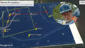
A 1934 blueprint tied to a Treasure Trove License has recently been used as an overlay to compare historic and modern coordinates. When plotted, it reveals two separate Money Pit positions—one at 165 feet, one at 295 feet—and suggests both locations were believed valid at different times.
Precise coordinates offered in the analysis are as follows:
-
165-ft Money Pit: 44° 30′ 45.14″ N, 64° 17′ 18.51″ W
-
295-ft Money Pit: 44° 30′ 46.41″ N, 64° 17′ 18.41″ W
-
Welling Triangle: 44° 30′ 43.56″ N, 64° 17′ 18.32″ W
The Mellon Triangle, another structural feature tied to Oak Island’s enigmatic geometry, lies southeast of these points.
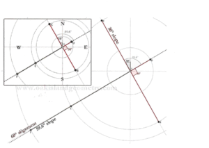
A 6.59° Clue in the Stones
Another striking detail concerns a 6.59-degree offset detected in both the Welling Triangle and the famous Nolan’s Cross. Researchers propose that both structures originally aligned to specific astronomical targets—most notably the Paris Observatory—before slowly drifting out of alignment due to changes in magnetic declination and the natural precession of Earth’s axis.
Using the precession rule of 72 years per degree, a drift of 6.59 degrees points to approximately 1551 AD as the year the structures reached their intended position. Some believe construction began around 1432, with the final placement of stones completed more than a century later.
A Site Marked for Centuries
One detail complicates the debate further: the Welling Triangle appears in Colonel Morris’s 1762 survey of Mahone Bay, long before modern treasure hunters arrived. Its presence confirms that at least some geometric markers on Oak Island predate the earliest Money Pit excavations.
A Mystery Still Deepening
Whether the Money Pit is misplaced, duplicated, or altered by centuries of environmental change remains uncertain. But one conclusion is increasingly clear: Oak Island’s geometry is older, more deliberate, and more complex than once believed. And as new interpretations emerge, the island’s long-buried puzzle only grows deeper.